
 If you've picked up a Nokia N82 black or upgrade your original N82 to the latest firmware then you now have geotagging built in. What this does exactly is imprint the exact gps location onto your jpeg file. There are certain programs that can read this data and lay them out on a map for you or categorize your photos based on the location they were taken. A few include Flickr, Google Maps and Google Earth. I also came across a few PC based programs that have even more detailed maps that you can overlay your photos on.
In this older post from a few weeks back I talked about uploading photos to Google Maps and embedding them anywhere on the web. You can look back read that article if you want an example of embedding into Google Maps.
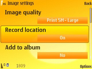
Before you start your own geotagged maps though you need to make sure of a few things. Go into your camera settings and enable record location. Then if your using Flickr to create the geofeed (the most common way) you gotta first go into the Flickr privacy settings and turn on the following...
When your logged into your Flickr, go to this page...
http://www.flickr.com/account/?tab=privacy
Scroll down to the area where it says "Defaults for new uploads" and you will see an option that says "import exif location data?". Click edit then click yes. Now any geotagged photo you upload Flickr will read the location data and allow you to put it on a map or give you the geofeed for embedding on other programs. Your geotagged photos that you have already uploaded won't show the location data, only newly uploaded photos.
Now when you go to your photo page you will see on the right side a "Taken In" line. Click the link "map" and you'll get just that - a map with your photo embedded. At the top of your Flickr page you can click Organize > Your Map. There you can find a full screen map of all your geotagged photos.
If you have a bunch of your photos from one even tagged you can view that tagged page and click "geofeed" at the bottom of the page. You will be given a link so that you can embed those photos into your Google Map or whatever map service that allows geofeeds.
Don't forget one thing though. These locations can be seen by anyone. If you want to erase the location data on a certain file look a few articles back here at the blog and read the guide. I got a few emails asking about this so that article should help.
For more information on geotagging with your N82 head over to this Howard Forums post where people are showing off their maps and giving eachother tips.
Have you mapped out your photos? If you have any you'd like to share, leave a comment below with a link to your map.
Tuesday, April 15, 2008
We Have Built In Geotagging. Now What?
Posted by Mike Macias at 2:02 PM
Related Topics: N82 Camera, N82 Geotagging, N82 GPS, N82 Tips
Posted by Mike Macias at 2:02 PM
What next?
You can also bookmark this post using your favorite bookmarking service:
Subscribe to:
Post Comments (Atom)


4 comments:
Thank you! I was trying to figure out how to enable the exif stuff in Flickr and couldn't do it! Thanks for the walk through.
http://www.flickr.com/photos/7852290@N02/2418766052
Click on map n u can see mine :)
fancy a tour around Ireland? here's my first try at geotagging...
Just came back from the CA Poppy fields...
http://picasaweb.google.com/lysine/APoppyDay/photo#map
Post a Comment
Please leave your screen name so I can refer to you if there are numerous comments. Thanks!